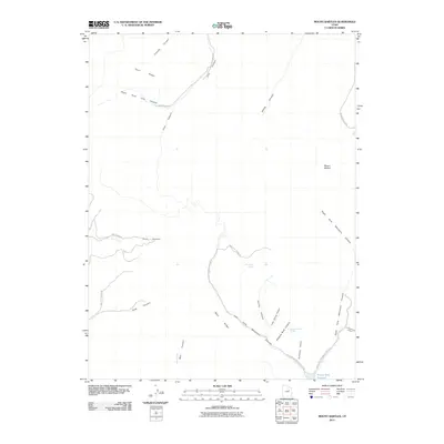
2011 Map of Mount Bartles
USGS Topo · Published 2011About this map
Mount Bartles dominates this high-elevation landscape in eastern Utah, serving as a central point for a complex network of drainages and ridgelines. The terrain is defined by dramatic elevation changes, where Twist Ridge and West Ridge divide deep-cut passages like Timothy Canyon and Cow Canyon. At the southern edge of the sheet, the Grassy Trail Reservoir marks a significant water collection point fed by the Left Fork Whitmore Canyon.
Find a feature on this map
29 named features on this map. Tap any name to fly to it.
Don’t see what you’re looking for? This feature index may not catch every label — zoom into the map to look around manually.
Map Details
Editions of this 2011 Mount Bartles Map
This is the sole edition of this map. No revisions or reprints were ever made.
Other maps of this area

1886 · Price River
USGS Topo · 1:250,000

1896 · Price River
USGS Topo · 1:250,000

1915 · Sunnyside
USGS Topo · 1:62,500

1915 · Wellington
USGS Topo · 1:62,500

1956 · Price
USGS Topo · 1:250,000

1960 · Price
USGS Topo · 1:250,000

1962 · Price
USGS Topo · 1:250,000

1968 · Wood Canyon
USGS Topo · 1:24,000
1968 · Currant Canyon
USGS Topo · 1:24,000
1969 · Minnie Maud Creek East
USGS Topo · 1:24,000