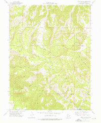
1972 Map of Mount Bartles
USGS Topo · Published 1976About this map
Mount Bartles dominates this high-altitude landscape in the 1970s, a region of Carbon County characterized by deep canyons and prominent ridges. The area reveals a history of resource extraction and water management, evidenced by a Mine and Drill Hole located within the rugged drainage of Rock Canyon. A network of Jeep Trail and Pack Trail routes traverses the steep slopes, connecting isolated water sources such as Dancohall Spring and Hanging Rock Spring. The eastern portion of the survey is defined by the significant descent into the Right Fork Whitmore Canyon, while the southern edge features the Grassy Trail Reservoir. This map documents a transitional period in Utah's high country where traditional land uses like mining and livestock grazing met increasing demands for watershed protection and geological survey.
Find a feature on this map
30 named features on this map. Tap any name to fly to it.
Don’t see what you’re looking for? This feature index may not catch every label — zoom into the map to look around manually.
Map Details
Editions of this 1972 Mount Bartles Map
This is the sole edition of this map. No revisions or reprints were ever made.
Other maps of this area

1886 · Price River
USGS Topo · 1:250,000

1896 · Price River
USGS Topo · 1:250,000

1915 · Sunnyside
USGS Topo · 1:62,500

1915 · Wellington
USGS Topo · 1:62,500

1956 · Price
USGS Topo · 1:250,000

1960 · Price
USGS Topo · 1:250,000

1962 · Price
USGS Topo · 1:250,000

1968 · Wood Canyon
USGS Topo · 1:24,000
1968 · Currant Canyon
USGS Topo · 1:24,000
1969 · Minnie Maud Creek East
USGS Topo · 1:24,000