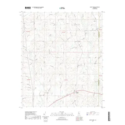
2018 Map of Mount Carmel
USGS Topo · Published 2018About this map
Clem and the surrounding Jefferson Davis County landscape are defined by an extensive network of family cemeteries and rural parishes. This 2018 survey reveals a topography deeply etched by the Bowie River and its tributaries, including White Sand Cr and Jaybird Cr. The distribution of historical markers like the Mount Carmel Cem and the Old Mount Harmony Cem suggests a long-established community structure where local genealogy is closely tied to specific land tracts and creek drainages. Small settlements are connected by a dense grid of named rural routes such as Williamson Mill Rd and Clem School Rd, reflecting a transportation pattern focused on local access rather than major regional thoroughfares. The presence of features like Betsy Spring and numerous unnamed smaller ponds indicates a high water table that has historically influenced settlement patterns and agriculture in this part of Mississippi.
Find a feature on this map
108 named features on this map. Tap any name to fly to it.
Don’t see what you’re looking for? This feature index may not catch every label — zoom into the map to look around manually.
Map Details
Editions of this 2018 Mount Carmel Map
This is the sole edition of this map. No revisions or reprints were ever made.
Other maps of this area

1953 · Hattiesburg
USGS Topo · 1:250,000

1958 · Hattiesburg
USGS Topo · 1:250,000

1970 · Prentiss West
USGS Topo · 1:24,000

1970 · New Hebron
USGS Topo · 1:24,000

1970 · Prentiss East
USGS Topo · 1:24,000

1970 · Mount Carmel
USGS Topo · 1:24,000
1971 · Shivers
USGS Topo · 1:24,000
1971 · Mendenhall SE
USGS Topo · 1:24,000

1974 · Lone Star
USGS Topo · 1:24,000

1974 · Lake Mike Connor
USGS Topo · 1:24,000