
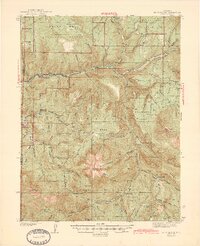
1945 Map of Mount Gunnison
USGS Topo · Published 1945About this map
The North Fork Gunnison River valley anchors this 1945 edition, showing the industrial and agricultural corridors of the West Slope just before the mid-century. Small settlements like Somerset and Oliver sit along the river's path, while the higher elevations of the Grand Mesa National Forest are marked by a network of seasonal work sites and shelters including Snowshoe Cabin, Bear Creek Cabin, and the Davenport Ranch.
Find a feature on this map
67 named features on this map. Tap any name to fly to it.
Don’t see what you’re looking for? This feature index may not catch every label — zoom into the map to look around manually.
Map Details
Editions of this 1945 Mount Gunnison Map
2 editions found
Other maps of this area

1888 · Anthracite
USGS Topo · 1:62,500

1889 · Anthracite
USGS Topo · 1:62,500

1893 · Anthracite
USGS Topo · 1:62,500

1894 · Anthracite
USGS Topo · 1:62,500

1938 · Mt. Gunnison
USGS Topo · 1:48,000

1956 · Montrose
USGS Topo · 1:250,000

1957 · Leadville
USGS Topo · 1:250,000

1959 · Leadville
USGS Topo · 1:250,000

1959 · Montrose
USGS Topo · 1:250,000

1960 · Leadville
USGS Topo · 1:250,000