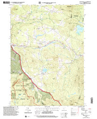
1997 Map of Mount Holly
USGS Topo · Published 2000About this map
Mount Holly and its surrounding hamlets are centers of settlement in this landscape of the Green Mountains, where the topography dictates a scattered pattern of villages following the winding course of the Mill River. These small communities, including East Wallingford, Tarbellville, and Belmont, are connected by a network of local roads and 4WD tracks that skirt high peaks like Ludlow Mtn and Hedgehog Hill. The presence of several Cem locations and family-named landmarks like Roger Hill and Hammond Hill provides a clear view of the area's social geography during the late 20th century.
Find a feature on this map
45 named features on this map. Tap any name to fly to it.
Don’t see what you’re looking for? This feature index may not catch every label — zoom into the map to look around manually.
Map Details
Editions of this 1997 Mount Holly Map
This is the sole edition of this map. No revisions or reprints were ever made.
Other maps of this area

1891 · Rutland
USGS Topo · 1:62,500

1893 · Wallingford
USGS Topo · 1:62,500

1893 · Rutland
USGS Topo · 1:62,500

1911 · Woodstock
USGS Topo · 1:62,500

1913 · Woodstock
USGS Topo · 1:62,500

1928 · Ludlow
USGS Topo · 1:48,000

1929 · Ludlow
USGS Topo · 1:62,500

1932 · Ludlow
USGS Topo · 1:62,500

1943 · Woodstock
USGS Topo · 1:62,500

1950 · Glens Falls
USGS Topo · 1:250,000