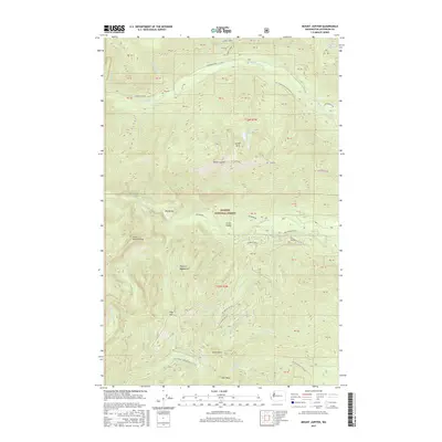
2017 Map of Mount Jupiter
USGS Topo · Published 2017About this map
Olympic National Forest land defines this corner of Jefferson County, dominated by the high ridgelines of the Olympic Mountains. The terrain is characterized by steep elevation gains between the Dosewallips River in the north and the Duckabush River to the south. This 2017 survey shows a network of Forest Service roads, such as Dosewallips Rd and Duckabush Rd, which provide access to the interior wilderness. Significant landmarks for hikers and geologists include Mount Jupiter, the Jupiter Hills, and the distinctive Saint Peters Dome. Water features are numerous, from the remote Jupiter Lakes to the dramatic Murhut Falls. Smaller drainages like Tunnel Creek, Stony Brook, and Fulton Cr feed into the primary river systems, illustrating the complex hydrology of the Olympic Peninsula.
Find a feature on this map
57 named features on this map. Tap any name to fly to it.
Don’t see what you’re looking for? This feature index may not catch every label — zoom into the map to look around manually.
Map Details
Editions of this 2017 Mount Jupiter Map
This is the sole edition of this map. No revisions or reprints were ever made.
Other maps of this area

1936 · Point Misery
USGS Topo · 1:62,500

1938 · Mt Constance
USGS Topo · 1:125,000

1940 · Point Misery
USGS Topo · 1:62,500

1940 · Quilcene
USGS Topo · 1:62,500

1946 · Tyler Peak
USGS Topo · 1:62,500

1947 · The Brothers
USGS Topo · 1:62,500

1948 · Tyler Peak
USGS Topo · 1:62,500

1950 · The Brothers
USGS Topo · 1:62,500

1953 · Mt. Walker
USGS Topo · 1:24,000
1953 · Brinnon
USGS Topo · 1:24,000