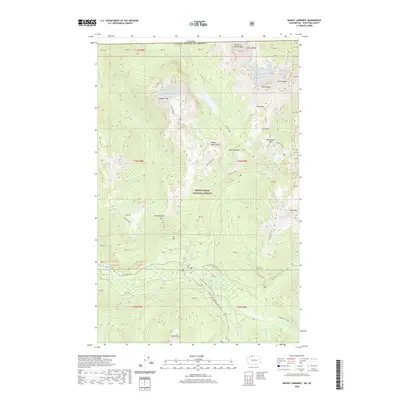
2020 Map of Mount Larrabee
USGS Topo · Published 2020About this map
American Border Peak and Mt Larrabee dominate this section of the Cascade Range along the international boundary between Canada and the United States. The 2020 landscape is defined by the high-elevation drainage basins of the N Fork Nooksack River, with several glacial features including the Nooksack Cirque and prominent alpine lakes like Tomyhoi Lake and Twin Lakes. The map highlights the intersection of heavy resource history and modern recreation, showing the site of the Lone Jack mine alongside the extensive path of the Pacific NW National Scenic Trail. Mountaineering landmarks such as Tomyhoi Peak, The Pleiades, and Winchester Mtn are detailed within the Mount Baker National Forest, illustrating the varied topography from the High Divide to the river valleys of Ruth Cr and Swamp Cr.
Find a feature on this map
36 named features on this map. Tap any name to fly to it.
Don’t see what you’re looking for? This feature index may not catch every label — zoom into the map to look around manually.
Map Details
Editions of this 2020 Mount Larrabee Map
This is the sole edition of this map. No revisions or reprints were ever made.
Other maps of this area

1909 · Mt Baker
USGS Topo · 1:192,000

1915 · Mt. Baker
USGS Topo · 1:250,000

1952 · Mt. Baker
USGS Topo · 1:62,500

1953 · Mt Shuksan
USGS Topo · 1:62,500

1955 · Concrete
USGS Topo · 1:250,000

1958 · Concrete
USGS Topo · 1:250,000

1962 · Concrete
USGS Topo · 1:250,000

1979 · Mt. Baker
USGS Topo · 1:100,000
1989 · Shuksan Arm
USGS Topo · 1:24,000
1989 · Mt Larrabee
USGS Topo · 1:24,000