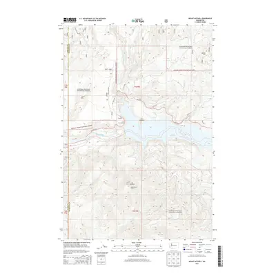
2013 Map of Mount Mitchell
USGS Topo · Published 2013About this map
Mt Mitchell and the Mount Mitchell Lookout anchor the high country in this portion of the Gifford Pinchot National Forest. This 2013 survey documents a landscape defined by the hydro-electric and timber management infrastructure within the Lewis River basin. Significant water features like the Swift Reservoir and the Swift Number Two Forebay demonstrate the mid-century engineering of the river, complemented by recreational and observational points such as the Swift Viewpoint and Swift Dam Overlook. The terrain transitions from the steep ridges of Marble Mtn and Devils Backbone to the drainage networks of Swift Cr and N Siouxon Cr. Forest development roads, including NFD 90 RD and Road 7900, provide the primary access through these wooded heights, where the borders of Cowlitz, Skamania, and Clark counties converge.
Find a feature on this map
31 named features on this map. Tap any name to fly to it.
Don’t see what you’re looking for? This feature index may not catch every label — zoom into the map to look around manually.
Map Details
Editions of this 2013 Mount Mitchell Map
This is the sole edition of this map. No revisions or reprints were ever made.
Other maps of this area

1919 · Mount St Helens
USGS Topo · 1:125,000

1940 · Lookout Mtn
USGS Topo · 1:62,500

1941 · Yacolt
USGS Topo · 1:62,500

1948 · Vancouver
USGS Topo · 1:250,000

1950 · Vancouver
USGS Topo · 1:250,000

1950 · Vancouver
USGS Topo · 1:250,000

1953 · Hoquiam
USGS Topo · 1:250,000

1953 · Lookout Mtn
USGS Topo · 1:62,500

1953 · Cougar
USGS Topo · 1:62,500
1956 · Yacolt
USGS Topo · 1:62,500