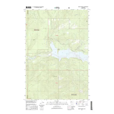
2017 Map of Mount Mitchell
USGS Topo · Published 2017About this map
Gifford Pinchot National Forest encompasses this stretch of the Cascade Range, dominated by the waters of the Lewis River system. The central focus is the large Swift Reservoir, held behind the dam infrastructure that includes the Swift Number Two Forebay. This 2017 survey details the complex network of Forest Service roads, such as Nat For Dev Rd 90 and Nat For Dev Rd 83, that provide access to the timber and recreation lands near the Cowlitz and Skamania County line. The terrain is defined by prominent peaks including Mount Mitchell and Green Mtn, while the Devils Backbone ridge separates the reservoir from the drainages of Swift Cr and the W Fork Swift Cr. Numerous smaller waterways like Rain Cr and N Siouxon Cr feed into the primary river valley, illustrating the hydrologic importance of this protected forest landscape.
Find a feature on this map
31 named features on this map. Tap any name to fly to it.
Don’t see what you’re looking for? This feature index may not catch every label — zoom into the map to look around manually.
Map Details
Editions of this 2017 Mount Mitchell Map
This is the sole edition of this map. No revisions or reprints were ever made.
Other maps of this area

1919 · Mount St Helens
USGS Topo · 1:125,000

1940 · Lookout Mtn
USGS Topo · 1:62,500

1941 · Yacolt
USGS Topo · 1:62,500

1948 · Vancouver
USGS Topo · 1:250,000

1950 · Vancouver
USGS Topo · 1:250,000

1950 · Vancouver
USGS Topo · 1:250,000

1953 · Hoquiam
USGS Topo · 1:250,000

1953 · Lookout Mtn
USGS Topo · 1:62,500

1953 · Cougar
USGS Topo · 1:62,500
1956 · Yacolt
USGS Topo · 1:62,500