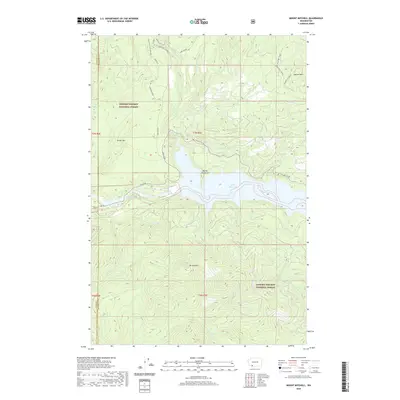
2020 Map of Mount Mitchell
USGS Topo · Published 2020About this map
Mt Mitchell rises as a prominent landmark in the southern reaches of the Gifford Pinchot National Forest, overseeing a landscape defined by volcanic geology and hydroelectric development. The Lewis River corridor is dominated by the expansive Swift Reservoir and the engineered Swift Number Two Forebay, reflecting the 20th-century transformation of the river for power generation. To the north, the terrain reveals its subterranean character with the presence of Ape Cave and the Lower Ape Cave, part of a network of lava tubes near Marble Mtn. Recreation and forestry infrastructure are integrated into this wilderness, from the Kalama Ski Trail and seasonal tracks like Road 8100 to the rugged topography of Lava Canyon and Cinnamon Peak. The map also documents the intersecting boundaries of Cowlitz, Skamania, and Clark counties.
Find a feature on this map
36 named features on this map. Tap any name to fly to it.
Don’t see what you’re looking for? This feature index may not catch every label — zoom into the map to look around manually.
Map Details
Editions of this 2020 Mount Mitchell Map
This is the sole edition of this map. No revisions or reprints were ever made.
Other maps of this area

1919 · Mount St Helens
USGS Topo · 1:125,000

1940 · Lookout Mtn
USGS Topo · 1:62,500

1941 · Yacolt
USGS Topo · 1:62,500

1948 · Vancouver
USGS Topo · 1:250,000

1950 · Vancouver
USGS Topo · 1:250,000

1950 · Vancouver
USGS Topo · 1:250,000

1953 · Hoquiam
USGS Topo · 1:250,000

1953 · Lookout Mtn
USGS Topo · 1:62,500

1953 · Cougar
USGS Topo · 1:62,500
1956 · Yacolt
USGS Topo · 1:62,500