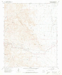
1967 Map of Mount Nutt
USGS Topo · Published 1980About this map
The Black Mountains dominate this 1967 survey of Arizona's high desert, revealing a landscape defined by mining history and rugged terrain. Mining heritage is central to the area, evidenced by the Goldroad Mine, Black Eagle Mine, and the Gold Trail Mine, along with various Tailings and unnamed Mines. These operations are clustered near the historic Sitgreaves Pass and the settlement at Eds Camp, illustrating the localized mineral boom that shaped this portion of Mohave County.
Find a feature on this map
45 named features on this map. Tap any name to fly to it.
Don’t see what you’re looking for? This feature index may not catch every label — zoom into the map to look around manually.
Map Details
Editions of this 1967 Mount Nutt Map
3 editions found
Other maps of this area

1886 · Camp Mohave
USGS Topo · 1:250,000

1892 · Camp Mohave
USGS Topo · 1:250,000

1903 · Needles
USGS Topo · 1:125,000

1904 · Needles Special
USGS Topo · 1:125,000

1927 · Yucca
USGS Topo · 1:62,500

1929 · Yucca
USGS Topo · 1:62,500

1942 · Camp Mohave
USGS Topo · 1:250,000

1947 · Kingman
USGS Topo · 1:250,000

1948 · Kingman
USGS Topo · 1:250,000

1954 · Needles
USGS Topo · 1:250,000