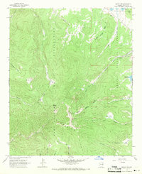
1967 Map of Mount Ord
USGS Topo · Published 1971About this map
Baldy Peak and Mount Ord dominate this high-altitude landscape in the late 1960s, marking the rugged boundary between the Fort Apache Indian Reservation and the Apache National Forest. The map reveals a complex hydrologic system where the headwaters of several major rivers originate, including the West Fork Little Colorado River and the East Fork White River. This area is characterized by numerous alpine meadows or cienegas, such as Purcell Cienega, Smith Cienega, and Bonito Cienega, which serve as vital water sources in this mountainous terrain. Human presence is sparse and concentrated along the edges, represented by the Slade Ranch to the north and Darnall Cabin near the southern boundary. A network of pack trails and jeep trails provides the only access through the dense topography, illustrating the area's role as a protected wilderness and managed forest land at the time of the survey.
Find a feature on this map
39 named features on this map. Tap any name to fly to it.
Don’t see what you’re looking for? This feature index may not catch every label — zoom into the map to look around manually.
Map Details
Editions of this 1967 Mount Ord Map
This is the sole edition of this map. No revisions or reprints were ever made.
Other maps of this area

1886 · St Johns
USGS Topo · 1:250,000

1892 · St Johns
USGS Topo · 1:250,000

1922 · Nutrioso
USGS Topo · 1:125,000

1954 · Clifton
USGS Topo · 1:250,000

1954 · Saint Johns
USGS Topo · 1:250,000

1957 · Clifton
USGS Topo · 1:250,000

1957 · Saint Johns
USGS Topo · 1:250,000

1958 · Clifton
USGS Topo · 1:250,000

1958 · Saint Johns
USGS Topo · 1:250,000

1958 · Big Lake
USGS Topo · 1:62,500