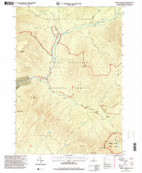
1995 Map of Mount Osceola
USGS Topo · Published 2000About this map
White Mountain National Forest dominates this mid-1990s survey, illustrating a landscape defined by conservation and recreation. The Kancamagus Highway snakes through the southern half of the quadrangle, serving as the primary corridor for access to the Pemigewasset Wilderness and the Greeley Ponds Scenic Area. At the northern end, the confluence of Lincoln Brook and Franconia Brook marks the site of the Franconia Brook Campsite, a key junction for hikers near Franconia Falls. The map reveals a transition in land use from historical extraction to modern preservation, where old routes like the Franconia Brook Trail and Greeley Ponds Trail follow the natural drainages of the Pemigewasset River and its branches. High peaks including Mount Osceola, Mount Hitchcock, and Whaleback Mountain surround deep notches like Mad River Notch, showing the challenging topography that shaped the development of this New Hampshire backcountry.
Find a feature on this map
55 named features on this map. Tap any name to fly to it.
Don’t see what you’re looking for? This feature index may not catch every label — zoom into the map to look around manually.
Map Details
Editions of this 1995 Mount Osceola Map
This is the sole edition of this map. No revisions or reprints were ever made.
Other maps of this area

1895 · Crawford Notch
USGS Topo · 1:62,500

1896 · Crawford Notch
USGS Topo · 1:62,500

1928 · Plymouth
USGS Topo · 1:62,500

1929 · Franconia
USGS Topo · 1:62,500

1931 · Plymouth
USGS Topo · 1:62,500

1931 · Mt. Chocorua
USGS Topo · 1:62,500

1932 · Franconia
USGS Topo · 1:62,500

1946 · Crawford Notch
USGS Topo · 1:62,500

1949 · Portland
USGS Topo · 1:250,000
1950 · Crawford Notch
USGS Topo · 1:62,500