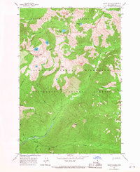
1966 Map of Mount Paloma
USGS Topo · Published 1968About this map
Nez Perce National Forest and the Bitterroot National Forest meet in this 1960s survey of the high backcountry in Idaho County. The landscape is defined by the high peaks of Mount Paloma and Cuneo Point, which mark the divide between different drainage basins. To the north, Brushy Fork Creek and its associated mountain lakes, including Emerald Lake and Brushy Fork Lake, feed into the larger waterway network. To the south, White Cap Creek flows through Canyon Creek and past Cooper Flat. The map highlights a series of high-altitude points such as Nipple Knob and Vance Point, connected by an extensive network of Pack Trails that provided the primary means of traversal through the Selway-Bitterroot Wilderness before modern road development.
Find a feature on this map
28 named features on this map. Tap any name to fly to it.
Don’t see what you’re looking for? This feature index may not catch every label — zoom into the map to look around manually.
Map Details
Editions of this 1966 Mount Paloma Map
2 editions found
Other maps of this area

1901 · Hamilton
USGS Topo · 1:125,000

1911 · Lolo
USGS Topo · 1:250,000

1913 · Lolo
USGS Topo · 1:250,000

1956 · Elk City
USGS Topo · 1:250,000

1956 · Hamilton
USGS Topo · 1:250,000

1959 · Hamilton
USGS Topo · 1:250,000

1960 · Elk City
USGS Topo · 1:250,000

1960 · Hamilton
USGS Topo · 1:250,000

1964 · Hamilton
USGS Topo · 1:250,000
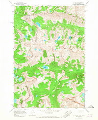
1964 · El Capitan
USGS Topo · 1:24,000