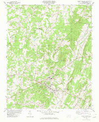
1980 Map of Mount Pleasant
USGS Topo · Published 1980About this map
Mount Pleasant serves as the central hub of this North Carolina Piedmont landscape, where the rolling hills of the Cabarrus Co and Stanly Co border are defined by a dense network of watercourses. The drainage of Dutch Buffalo Creek, Adams Creek, and Wolf Jennie Creek carves the terrain, supporting a rural community tied together by numerous country churches such as Prosperity Ch, Mt Carmel Ch, and Mt Olive Ch.
Find a feature on this map
32 named features on this map. Tap any name to fly to it.
Don’t see what you’re looking for? This feature index may not catch every label — zoom into the map to look around manually.
Map Details
Editions of this 1980 Mount Pleasant Map
This is the sole edition of this map. No revisions or reprints were ever made.
Other maps of this area

1893 · Statesville
USGS Topo · 1:125,000

1941 · Charlotte
USGS Topo · 1:125,000

1942 · Charlotte
USGS Topo · 1:125,000

1949 · Concord SE
USGS Topo · 1:24,000

1950 · Concord
USGS Topo · 1:24,000

1953 · Charlotte
USGS Topo · 1:250,000

1954 · Charlotte
USGS Topo · 1:250,000

1957 · Mount Pleasant
USGS Topo · 1:62,500

1960 · Charlotte
USGS Topo · 1:250,000

1962 · Charlotte
USGS Topo · 1:250,000