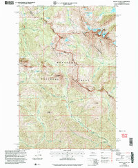
2003 Map of Mount Stuart
USGS Topo · Published 2006About this map
Mount Stuart dominates this high-altitude landscape along the border of Chelan and Kittitas Counties, where the Stuart Range and the Alpine Lakes Wilderness converge. The topography is defined by significant ice masses including the Stuart Glacier, Ice Cliff Glacier, and Sherman Glacier. For local historians and researchers, the map reveals a history of extraction with multiple prospects, an Adit, and Mine Shafts Adit concentrated near Van Epps Pass. The drainage patterns of the North Fork and Middle Fork Teanaway River create a complex network of basins holding high-mountain waters such as Lake Ingalls, Lake Ann, and the curiously named Lake Camp Fire Girls. This U.S. Forest Service revision documents the area within the Wenatchee National Forest, showing the primitive routes and landmarks like the Footbridge over De Roux Creek that served late-20th-century backcountry travelers.
Find a feature on this map
54 named features on this map. Tap any name to fly to it.
Don’t see what you’re looking for? This feature index may not catch every label — zoom into the map to look around manually.
Map Details
Editions of this 2003 Mount Stuart Map
This is the sole edition of this map. No revisions or reprints were ever made.
Other maps of this area

1897 · Mount Stuart
USGS Topo · 1:125,000

1901 · Chiwaukum
USGS Topo · 1:125,000

1901 · Snoqualmie Pass
USGS Topo · 1:125,000

1902 · Skykomish
USGS Topo · 1:125,000

1902 · Mount Stuart
USGS Topo · 1:125,000

1903 · Snoqualmie
USGS Topo · 1:125,000

1904 · Chiwaukum
USGS Topo · 1:125,000

1905 · Skykomish
USGS Topo · 1:125,000

1957 · Wenatchee
USGS Topo · 1:250,000

1961 · Mount Stuart
USGS Topo · 1:62,500