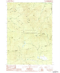
1987 Map of Mount Tripyramid
USGS Topo · Published 1987About this map
Mount Tripyramid dominates this 1980s landscape, which centers on the high-elevation terrain where the Livermore and Albany boundaries meet. This survey shows the extensive network of trails and wilderness areas before modern forest management changes, including the Pine Bend Trail and the Sabbaday Brook Trail leading toward Potash Mtn. The map preserves the names of numerous hydrological features like Sabbaday Falls, Fletcher Cascades, and Norway Rapids, illustrating the steep descent from the peaks into the Swift River and Whiteface River basins.
Find a feature on this map
65 named features on this map. Tap any name to fly to it.
Don’t see what you’re looking for? This feature index may not catch every label — zoom into the map to look around manually.
Map Details
Editions of this 1987 Mount Tripyramid Map
This is the sole edition of this map. No revisions or reprints were ever made.
Other maps of this area

1895 · Crawford Notch
USGS Topo · 1:62,500

1896 · Crawford Notch
USGS Topo · 1:62,500

1928 · Plymouth
USGS Topo · 1:62,500

1929 · Franconia
USGS Topo · 1:62,500

1931 · Plymouth
USGS Topo · 1:62,500

1931 · Mt. Chocorua
USGS Topo · 1:62,500

1932 · Franconia
USGS Topo · 1:62,500

1946 · Crawford Notch
USGS Topo · 1:62,500

1949 · Portland
USGS Topo · 1:250,000
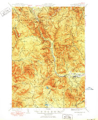
1950 · Crawford Notch
USGS Topo · 1:62,500