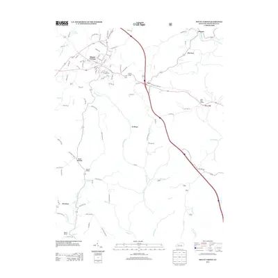
2013 Map of Mount Vernon
USGS Topo · Published 2013About this map
Mount Vernon serves as the focal point of this 2013 survey, where a complex network of local streets like Neggortown Hill Rd and Greenway Dr branch out toward the surrounding countryside. The landscape is defined by the winding waters of E Fork Skegg Cr and Sinking Br, carving through a terrain of hollows including Hysinger Hollow and Lime Plant Hollow. Transportation routes dominate the eastern half of the map, with the interstate corridor and Old US Highway 25 N cutting through small settlements like Burr and Pine Hill. Local history and geology are evident in the naming of places like Flat Rock and Blue Springs, while the presence of Lake Linville to the northwest highlights the area's water management. This map illustrates the modern footprint of Rockcastle County, showing how established towns and rural outposts like Wellhope and Sand Springs are interconnected by both ancient hollows and contemporary highways.
Find a feature on this map
102 named features on this map. Tap any name to fly to it.
Don’t see what you’re looking for? This feature index may not catch every label — zoom into the map to look around manually.
Map Details
Editions of this 2013 Mount Vernon Map
This is the sole edition of this map. No revisions or reprints were ever made.
Other maps of this area

1893 · London
USGS Topo · 1:125,000

1897 · London
USGS Topo · 1:125,000

1952 · Billows
USGS Topo · 1:24,000

1952 · Shopville
USGS Topo · 1:24,000

1952 · Bernstadt
USGS Topo · 1:24,000

1953 · Johnetta
USGS Topo · 1:24,000

1953 · Maretburg
USGS Topo · 1:24,000

1953 · Wildie
USGS Topo · 1:24,000

1953 · Livingston
USGS Topo · 1:24,000
1953 · Brodhead
USGS Topo · 1:24,000