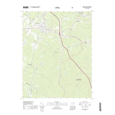
2019 Map of Mount Vernon
USGS Topo · Published 2019About this map
Mount Vernon serves as the central hub of this Rockcastle County landscape, where the convergence of the Interstate 75 corridor and several historical routes meets the edge of the Daniel Boone National Forest. The map documents a classic Appalachian transition from the dense street grid of the county seat to the dispersed rural settlements of Orlando, Pine Hill, and Sand Springs. Local history is preserved in the numerous family and community burial grounds, such as Elmwood Cem and the McKinney Cem situated near the headwaters of Skaggs Cr. The terrain is deeply carved by drainage systems like Roundstone Creek and E Fork Skaggs Cr, creating isolated pockets such as Lime Plant Hollow and Marler Hollow. These features illustrate the enduring influence of the Cumberland Plateau's geography on transit and settlement patterns into the twenty-first century.
Find a feature on this map
95 named features on this map. Tap any name to fly to it.
Don’t see what you’re looking for? This feature index may not catch every label — zoom into the map to look around manually.
Map Details
Editions of this 2019 Mount Vernon Map
This is the sole edition of this map. No revisions or reprints were ever made.
Other maps of this area

1893 · London
USGS Topo · 1:125,000

1897 · London
USGS Topo · 1:125,000

1952 · Billows
USGS Topo · 1:24,000

1952 · Shopville
USGS Topo · 1:24,000

1952 · Bernstadt
USGS Topo · 1:24,000

1953 · Johnetta
USGS Topo · 1:24,000

1953 · Maretburg
USGS Topo · 1:24,000

1953 · Wildie
USGS Topo · 1:24,000

1953 · Livingston
USGS Topo · 1:24,000
1953 · Brodhead
USGS Topo · 1:24,000