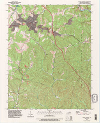
1993 Map of Mount Vernon
USGS Topo · Published 1996About this map
The county seat of Mount Vernon serves as the central hub for this portion of Rockcastle County during the mid-1990s, where the industrial presence of Quarry sites and numerous Strip Mine operations highlight the region's reliance on mineral extraction. The landscape is defined by the sharp transition between developed corridors and the protected woodlands of the Daniel Boone National Forest, which covers much of the eastern terrain. Transportation is dominated by the CSX Transportation line and the modern infrastructure of Interchange 62 and Interchange 59, showing how the area adapted to interstate travel while maintaining older connection points like Henderson Road. Small rural settlements such as Sand Springs, Pine Hill, and Orlando are tucked into the valleys, often organized around water sources like Roundstone Creek and Lake Linville, preserving a traditional Kentucky settlement pattern alongside modern industrial footprints.
Find a feature on this map
47 named features on this map. Tap any name to fly to it.
Don’t see what you’re looking for? This feature index may not catch every label — zoom into the map to look around manually.
Map Details
Editions of this 1993 Mount Vernon Map
This is the sole edition of this map. No revisions or reprints were ever made.
Other maps of this area

1893 · London
USGS Topo · 1:125,000

1897 · London
USGS Topo · 1:125,000

1952 · Billows
USGS Topo · 1:24,000

1952 · Shopville
USGS Topo · 1:24,000

1952 · Bernstadt
USGS Topo · 1:24,000

1953 · Johnetta
USGS Topo · 1:24,000

1953 · Maretburg
USGS Topo · 1:24,000

1953 · Wildie
USGS Topo · 1:24,000

1953 · Livingston
USGS Topo · 1:24,000
1953 · Brodhead
USGS Topo · 1:24,000