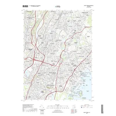
2019 Map of Mount Vernon
USGS Topo · Published 2019About this map
Saint Paul's Church National Historic Site stands as a focal point in this densely developed corridor of Westchester and the Bronx. The landscape is a complex network of established neighborhoods and major transit arteries, including the Metro-North rail line and the Hutchinson River Pkwy. From the banks of the Hudson River at Dobbs Ferry and Hastings-on-Hudson to the inlets of the Long Island Sound, the area is defined by its transition from urban density to suburban residential tracts like Crestwood Gardens and Lawrence Park. This survey illustrates the intricate social infrastructure of the mid-20th century, marking numerous religious and educational institutions such as Saint Josephs Seminary Dunwoodie and Iona College. The coastline along Echo Bay reveals a scattered archipelago of islands, including Glen Island and Davids Island, which separate the mainland from the open waters of the sound.
Find a feature on this map
154 named features on this map. Tap any name to fly to it.
Don’t see what you’re looking for? This feature index may not catch every label — zoom into the map to look around manually.
Map Details
Editions of this 2019 Mount Vernon Map
This is the sole edition of this map. No revisions or reprints were ever made.
Other maps of this area

1891 · Harlem
USGS Topo · 1:62,500

1892 · Stamford
USGS Topo · 1:62,500

1892 · Tarrytown
USGS Topo · 1:62,500

1893 · Stamford
USGS Topo · 1:62,500

1893 · Tarrytown
USGS Topo · 1:62,500

1897 · Harlem
USGS Topo · 1:62,500

1897 · Oyster Bay
USGS Topo · 1:62,500

1898 · Harlem
USGS Topo · 1:62,500

1898 · Oyster Bay
USGS Topo · 1:62,500

1899 · Stamford
USGS Topo · 1:62,500