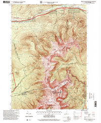
1995 Map of Mount Washington
USGS Topo · Published 1999About this map
Mount Washington dominates this high-altitude landscape, a focal point for late twentieth-century recreation and infrastructure in the Presidential Range. The summit is marked by Communication Towers and Mount Washington State Park, served by the famous Cog Railroad ascending from Base Station and Marshfield Station. The map illustrates the complex network of footpaths that define the White Mountains, including the Appalachian Trail as it traverses the Great Gulf Wilderness and the Alpine Garden Research Natural Area. Alpine accommodations such as Madison Hut, Lakes of the Clouds Hut, and the Perch Shelter provide critical points of interest for historical research into the development of New England's backcountry tourism. To the north, the corridor through Randolph shows the transition from valley settlements like Bowman and Appalachia to the steep ascent of Mount Adams and Mount Madison.
Find a feature on this map
147 named features on this map. Tap any name to fly to it.
Don’t see what you’re looking for? This feature index may not catch every label — zoom into the map to look around manually.
Map Details
Editions of this 1995 Mount Washington Map
This is the sole edition of this map. No revisions or reprints were ever made.
Other maps of this area

1893 · Mt. Washington
USGS Topo · 1:62,500

1893 · Gorham
USGS Topo · 1:62,500

1894 · North Conway
USGS Topo · 1:62,500

1895 · Crawford Notch
USGS Topo · 1:62,500

1896 · Mt. Washington
USGS Topo · 1:62,500

1896 · Crawford Notch
USGS Topo · 1:62,500

1896 · North Conway
USGS Topo · 1:62,500

1896 · Gorham
USGS Topo · 1:62,500

1935 · Mt. Washington
USGS Topo · 1:62,500

1937 · Gorham
USGS Topo · 1:48,000
Featured Places
- Randolph, NH
- Bean's Grant, NH
- Bowman, Randolph
- Crawford's Purchase, NH
- Thompson and Meserve's Purchase, NH