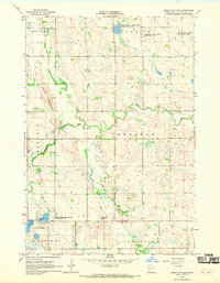
1967 Map of Mount Wickham
USGS Topo · Published 1969About this map
Mount Wickham rises as a prominent landmark in this western Minnesota prairie landscape, which is defined by the intricate meandering of the Lac qui Parle River and its West Branch. The 1960s terrain shows a region carefully partitioned into townships including Augusta, Arena, Mehurin, Garfield, Manfred, and Freeland. The distribution of water features like Florida Creek, Cobb Creek, and the Bolland Sloughs highlights the importance of drainage and conservation in this agricultural area. Dedicated conservation efforts are evident in the established boundaries of the Haydenville State Wildlife Management Area, Kemen State Wildlife Management Area, and Sweetwater State Wildlife Management Area, preserving vital wetlands and habitats amidst the surveyed fields.
Find a feature on this map
16 named features on this map. Tap any name to fly to it.
Don’t see what you’re looking for? This feature index may not catch every label — zoom into the map to look around manually.
Map Details
Editions of this 1967 Mount Wickham Map
This is the sole edition of this map. No revisions or reprints were ever made.
Other maps of this area

1953 · Bellingham
USGS Topo · 1:62,500

1953 · Milbank
USGS Topo · 1:250,000

1953 · Watertown
USGS Topo · 1:250,000

1958 · Milbank
USGS Topo · 1:250,000

1958 · Watertown
USGS Topo · 1:250,000

1958 · Madison
USGS Topo · 1:24,000

1967 · Dawson SW
USGS Topo · 1:24,000

1967 · Gary
USGS Topo · 1:24,000

1967 · Gary SE
USGS Topo · 1:24,000

1967 · Gary NW
USGS Topo · 1:24,000