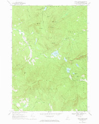
1967 Map of Mount Zircon
USGS Topo · Published 1969About this map
Mount Zircon and the surrounding peaks of Oxford County dominate this 1967 survey, providing a snapshot of the Maine highlands before significant modern development. The landscape is defined by the headwaters of the Nezinscot River and a collection of high-elevation water bodies including Concord Pond and Shagg Pond. Local industry and infrastructure are represented by a Quarry and Gravel Pit at the southern edge, while the historical Mt Zircon Spring and a Lookout Tower mark the summits. Scattered settlements like East Milton and Redding are connected by narrow roads such as Maine 219, reflecting the era's rural character. Genealogists may find interest in the Greenleaf Cem and other cemeteries that anchor these small upland communities near the Concord River valley.
Find a feature on this map
45 named features on this map. Tap any name to fly to it.
Don’t see what you’re looking for? This feature index may not catch every label — zoom into the map to look around manually.
Map Details
Editions of this 1967 Mount Zircon Map
This is the sole edition of this map. No revisions or reprints were ever made.
Other maps of this area

1911 · Bryant Pond
USGS Topo · 1:62,500

1911 · Buckfield
USGS Topo · 1:62,500

1913 · Buckfield
USGS Topo · 1:62,500

1914 · Bryant Pond
USGS Topo · 1:62,500

1926 · Dixfield
USGS Topo · 1:62,500

1927 · Rumford
USGS Topo · 1:48,000

1929 · Dixfield
USGS Topo · 1:62,500

1930 · Rumford
USGS Topo · 1:62,500

1942 · Buckfield
USGS Topo · 1:62,500

1942 · Bryant Pond
USGS Topo · 1:62,500