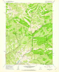
1961 Map of Mountain Dell
USGS Topo · Published 1963About this map
The Mormon Pioneer Trail and the Route of Donner-Reed Party converge in this high-altitude landscape east of Salt Lake City, documenting the difficult paths taken by early western emigrants. This 1961 survey details the intersection of historic transit and modern utility, where pipelines and jeep trails now cross the same ridges once traversed by wagons. Landmarks like the Ephraim Hanks Station Pony Express Marker and the Last Camp (Hist Mon) monument provide specific points for historical reconstruction.
Find a feature on this map
70 named features on this map. Tap any name to fly to it.
Don’t see what you’re looking for? This feature index may not catch every label — zoom into the map to look around manually.
Map Details
Editions of this 1961 Mountain Dell Map
4 editions found
Other maps of this area

1885 · Salt Lake
USGS Topo · 1:250,000

1925 · Ft. Douglas
USGS Topo · 1:125,000

1928 · Ft. Douglas
USGS Topo · 1:125,000

1950 · Fort Douglas
USGS Topo · 1:24,000

1951 · Fort Douglas
USGS Topo · 1:24,000

1952 · Sugar House
USGS Topo · 1:24,000

1952 · Bountiful Peak
USGS Topo · 1:24,000

1954 · Salt Lake City
USGS Topo · 1:250,000

1955 · Mount Aire
USGS Topo · 1:24,000

1955 · Park City West
USGS Topo · 1:24,000