1981 Map of Mountain View
USGS Topo · Published 1981About this map
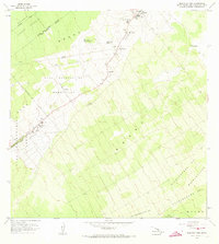
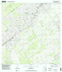
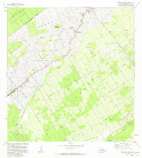
Agricultural and residential development in the Puna District is clearly defined in this 1981 revision, centered on the communities of Mountain View and Kurtistown. The map illustrates the structured land divisions of the Ola A Homesteads and Ola A Lots, reflecting a landscape of smallholdings and plantations. Several plantation camps, including Ninemile Camp, Iwasaki Camp, and Nine and Onehalf Mile Camp, speak to the region's labor history and the organization of the sugar and agricultural economy near Keaau. To the north and west, the map transitions into protected forest lands, including the Waiakea Forest Reserve and Ola A Reservation. Extensive road networks such as Stainback Highway and residential tracts like Orchid Land show the encroaching suburban growth into formerly rural and wooded areas.
Find a feature on this map
48 named features on this map. Tap any name to fly to it.
Don’t see what you’re looking for? This feature index may not catch every label — zoom into the map to look around manually.
Map Details
Editions of this 1981 Mountain View Map
This is the sole edition of this map. No revisions or reprints were ever made.
Historical Maps of Kopua Farm Lots Through Time
6 maps found