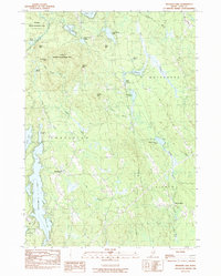
1983 Map of Mousam Lake
USGS Topo · Published 1983About this map
The Little Ossipee River and Middle Branch Mousam River define the hydraulic character of this York County landscape as it appeared in the early 1980s. The area is marked by numerous glacial ponds and lakes, including the expansive Mousam Lake and Square Pond, which serve as focal points for the surrounding settlements. Small communities like Shapleigh, Ross Corner, and North Alfred are connected by a network of local roads and unimproved trails that weave through the varied terrain of Fort Ridge and Hussey Mtn. Much of the northern portion is dedicated to the Newfield Wildlife Management Area, preserving the timbered highlands and wetlands near Silver Lake. This survey captures the rural transition of Southern Maine just before more modern residential expansion, documenting long-standing family-named landmarks like Abbott Mtn and Granny Kent Pond.
Find a feature on this map
39 named features on this map. Tap any name to fly to it.
Don’t see what you’re looking for? This feature index may not catch every label — zoom into the map to look around manually.
Map Details
Editions of this 1983 Mousam Lake Map
This is the sole edition of this map. No revisions or reprints were ever made.
Other maps of this area

1891 · Berwick
USGS Topo · 1:62,500

1891 · Kennebunk
USGS Topo · 1:62,500

1891 · Buxton
USGS Topo · 1:62,500

1891 · Newfield
USGS Topo · 1:62,500

1892 · Buxton
USGS Topo · 1:62,500

1893 · Kennebunk
USGS Topo · 1:62,500

1893 · Berwick
USGS Topo · 1:62,500

1893 · Buxton
USGS Topo · 1:62,500

1893 · Newfield
USGS Topo · 1:62,500

1898 · Kennebunk
USGS Topo · 1:62,500