
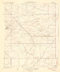
1929 Map of Mouth of Kern
USGS Topo · Published 1929About this map
Industrial expansion into the San Joaquin Valley is evident in this late-1920s topography, where the massive Buena Vista Lake Bed dominates the landscape south of the Elk Hills. The map captures a critical era for the region's energy sector, illustrating the physical infrastructure of the Honolulu Oil Company (Water Pumping Sta), the Midway Gas Company, and the Richfield Oil Company. These commercial installations and the accompanying Red Rim Tank Pipe sit adjacent to the protected lands of the Elk Hills Naval Reserve No. 1, highlighting the tension between private extraction and federal reserves during the period. Transport and irrigation networks are well-defined, from the Southern Pacific (Taft-Bakersfield Branch) running past Kyan Siding to the engineered paths of the Inlet Canal and Outlet Canal that manage the waters of the Kern River.
Find a feature on this map
20 named features on this map. Tap any name to fly to it.
Don’t see what you’re looking for? This feature index may not catch every label — zoom into the map to look around manually.
Map Details
Editions of this 1929 Mouth of Kern Map
This is the sole edition of this map. No revisions or reprints were ever made.
Other maps of this area

1910 · Buena Vista Lake
USGS Topo · 1:125,000

1912 · Buena Vista Lake
USGS Topo · 1:125,000

1929 · Stevens
USGS Topo · 1:31,680

1929 · Coles Levee
USGS Topo · 1:31,680

1930 · Millux
USGS Topo · 1:31,680

1931 · Pentland Junction
USGS Topo · 1:31,680

1931 · Hayes Ranch
USGS Topo · 1:31,680

1932 · East Elk Hills
USGS Topo · 1:31,680

1932 · Mouth of Kern
USGS Topo · 1:31,680
1932 · Stevens
USGS Topo · 1:31,680