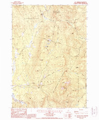
1987 Map of Mt. Cardigan
USGS Topo · Published 1987About this map
Mt Cardigan dominates this 1980s landscape, serving as the central hub for a network of drainages and recreational boundaries in Grafton County. The terrain is defined by its dramatic relief, from the peak of Firescrew down to the basins of Orange and Bucks Corner. The map illustrates the hydrology of the eastern slopes, where the South Branch Baker River and Cockermouth River begin their courses, carved between heights like Mowglis Mountain and Hoyt Hill. The presence of Mt Cardigan State Forest and Province Road State Forest indicates a landscape heavily managed for conservation and public use by the late 20th century. Local landmarks like Cilleys Cave and The Pinnacle suggest the area's long-standing draw for hikers and explorers, while a few scattered gravel pits and a mine hint at the small-scale extractive industry that persisted alongside the developing snowmobile trail network.
Find a feature on this map
43 named features on this map. Tap any name to fly to it.
Don’t see what you’re looking for? This feature index may not catch every label — zoom into the map to look around manually.
Map Details
Editions of this 1987 Mt. Cardigan Map
This is the sole edition of this map. No revisions or reprints were ever made.
Other maps of this area

1927 · Cardigan
USGS Topo · 1:62,500

1927 · Mascoma
USGS Topo · 1:62,500

1928 · Rumney
USGS Topo · 1:62,500

1930 · Cardigan
USGS Topo · 1:62,500

1931 · Mt. Cube
USGS Topo · 1:62,500

1932 · Mascoma
USGS Topo · 1:62,500

1932 · Rumney
USGS Topo · 1:62,500

1933 · Mt. Cube
USGS Topo · 1:62,500

1949 · Portland
USGS Topo · 1:250,000

1950 · Glens Falls
USGS Topo · 1:250,000