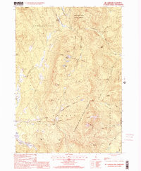
1998 Map of Mt. Cardigan
USGS Topo · Published 2001About this map
Cardigan Mtn State Forest dominates this landscape in Grafton County, where the high peaks of Mt Cardigan and Firescrew overlook a network of mountain brooks and small settlements. The terrain is defined by its steep elevations and clear drainage patterns, including the South Branch Baker River and the Cockermouth River. Small rural clusters like Bucks Corner and Orange are connected by local routes and the Province Road, while evidence of earlier land use is visible in the scattered gravel pits and a designated Mine near the western boundary.
Find a feature on this map
45 named features on this map. Tap any name to fly to it.
Don’t see what you’re looking for? This feature index may not catch every label — zoom into the map to look around manually.
Map Details
Editions of this 1998 Mt. Cardigan Map
This is the sole edition of this map. No revisions or reprints were ever made.
Other maps of this area

1927 · Cardigan
USGS Topo · 1:62,500

1927 · Mascoma
USGS Topo · 1:62,500

1928 · Rumney
USGS Topo · 1:62,500

1930 · Cardigan
USGS Topo · 1:62,500

1931 · Mt. Cube
USGS Topo · 1:62,500

1932 · Mascoma
USGS Topo · 1:62,500

1932 · Rumney
USGS Topo · 1:62,500

1933 · Mt. Cube
USGS Topo · 1:62,500

1949 · Portland
USGS Topo · 1:250,000

1950 · Glens Falls
USGS Topo · 1:250,000