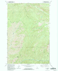
1991 Map of Mt George
USGS Topo · Published 1994About this map
Mt George stands as a prominent high point in this remote section of the Clearwater and Bitterroot mountains. The landscape is defined by the intersection of the Nez Perce National Forest and the Bitterroot National Forest, with a significant portion of the area designated as the Selway-Bitterroot Wilderness. Human presence is minimal, marked primarily by a series of Pack Trails that navigate the steep drainages of Brushy Fork Creek and White Cap Creek.
Find a feature on this map
19 named features on this map. Tap any name to fly to it.
Don’t see what you’re looking for? This feature index may not catch every label — zoom into the map to look around manually.
Map Details
Editions of this 1991 Mt George Map
This is the sole edition of this map. No revisions or reprints were ever made.
Other maps of this area

1911 · Lolo
USGS Topo · 1:250,000

1913 · Lolo
USGS Topo · 1:250,000

1956 · Elk City
USGS Topo · 1:250,000

1956 · Hamilton
USGS Topo · 1:250,000

1959 · Hamilton
USGS Topo · 1:250,000

1960 · Elk City
USGS Topo · 1:250,000

1960 · Hamilton
USGS Topo · 1:250,000

1964 · Hamilton
USGS Topo · 1:250,000

1966 · Watchtower Peak
USGS Topo · 1:24,000

1966 · Spot Mountain
USGS Topo · 1:24,000