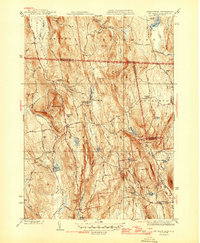
1946 Map of Mt Grace
USGS Topo · Published 1946About this map
Warwick and the surrounding borderlands of Massachusetts and New Hampshire appear here in a post-war revision reflecting the area's rural and recreational landscape in the mid-1940s. The terrain is characterized by numerous small ponds and mill sites, such as Richards Mill Pond and Wheeler Pond, interspersed with high points like Tully Mtn and the prominent Mt Grace Fire Tower. The settlement pattern centers on small crossroads such as Mayo Corners and Baptist Corners, while the presence of Camp Takodah and Camp Warwick suggests the region's established role as a summer destination.
Find a feature on this map
70 named features on this map. Tap any name to fly to it.
Don’t see what you’re looking for? This feature index may not catch every label — zoom into the map to look around manually.
Map Details
Editions of this 1946 Mt Grace Map
2 editions found
Other maps of this area

1887 · Warwick
USGS Topo · 1:62,500

1887 · Winchendon
USGS Topo · 1:62,500

1889 · Warwick
USGS Topo · 1:62,500

1890 · Winchendon
USGS Topo · 1:62,500

1894 · Winchendon
USGS Topo · 1:62,500

1894 · Warwick
USGS Topo · 1:62,500

1898 · Monadnock
USGS Topo · 1:62,500

1898 · Keene
USGS Topo · 1:62,500

1932 · Warwick
USGS Topo · 1:48,000

1932 · Winchendon
USGS Topo · 1:48,000