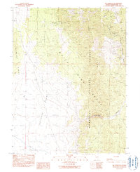
1990 Map of Mt. Hamilton
USGS Topo · Published 1990About this map
Silver mining history dominates this 1990 survey of the White Pine mining district, where the ghost towns of Monte Cristo (Site), Shermantown (Site), and Swansea (Site) are preserved as historical markers on the landscape. The terrain transitions from the high peaks of the White Pine Range and Humboldt National Forest down into the broad expanse of Railroad Valley. Numerous shafts and prospects, including the Ne Plus Ultra Mine and Grand Prize Mine, are concentrated along Babylon Ridge and Hamilton Ridge, tracing the intensive subterranean activity of the late 19th-century silver rush. Reliable water sources like Hoppe Spring and Monte Cristo Spring were critical for these isolated camps, while deep drainages such as Cathedral Canyon and McEllen Canyon define the high-elevation relief east of Pancake Range.
Find a feature on this map
27 named features on this map. Tap any name to fly to it.
Don’t see what you’re looking for? This feature index may not catch every label — zoom into the map to look around manually.
Map Details
Editions of this 1990 Mt. Hamilton Map
This is the sole edition of this map. No revisions or reprints were ever made.
Other maps of this area

1949 · Treasure Hill
USGS Topo · 1:62,500

1950 · Treasure Hill
USGS Topo · 1:62,500

1951 · Green Springs
USGS Topo · 1:62,500

1951 · Illipah
USGS Topo · 1:62,500

1951 · Pancake Summit
USGS Topo · 1:62,500

1956 · Ely
USGS Topo · 1:250,000

1959 · Ely
USGS Topo · 1:250,000

1963 · Ely
USGS Topo · 1:250,000

1979 · Mt. Hamilton
USGS Topo · 1:100,000

1990 · Pancake Summit SW
USGS Topo · 1:24,000