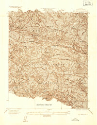
1934 Map of Mt. Lowe
USGS Topo · Published 1934About this map
The San Gabriel Mountains provide a dramatic backdrop for this mid-1930s survey, capturing the complex network of mountain resorts and technical infrastructure above Pasadena. This era represents a peak for the region's mountain tourism, centered around the engineering marvel of the Mt Lowe Ry, which winds its way toward the Mt Lowe Tavern and the overlook at Inspiration Point. The landscape is dotted with early 20th-century recreational sites like Switzers Camp and Oakwilde, reflecting the heavy public use of the Angeles National Forest.
Find a feature on this map
37 named features on this map. Tap any name to fly to it.
Don’t see what you’re looking for? This feature index may not catch every label — zoom into the map to look around manually.
Map Details
Editions of this 1934 Mt. Lowe Map
This is the sole edition of this map. No revisions or reprints were ever made.
Other maps of this area

1894 · Los Angeles
USGS Topo · 1:62,500

1896 · Pasadena
USGS Topo · 1:62,500

1900 · Pasadena
USGS Topo · 1:62,500

1900 · Tujunga
USGS Topo · 1:62,500

1900 · Los Angeles
USGS Topo · 1:62,500

1901 · Southern California Sheet No. 1
USGS Topo · 1:250,000

1904 · Southern California Sheet No. 1
USGS Topo · 1:250,000
1928 · Altadena
USGS Topo · 1:24,000
1928 · La Crescenta
USGS Topo · 1:24,000
1928 · Sierra Madre
USGS Topo · 1:24,000