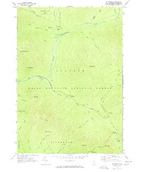
1967 Map of Mt. Osceola
USGS Topo · Published 1972About this map
White Mountain National Forest dominates this topographic survey, centering on the high peaks and deep drainages of the Lincoln and Livermore townships. The landscape is defined by the East Branch Pemigewasset River and its numerous tributaries, including Hancock Branch and Franconia Brook. In the late 1960s, this area was a focal point for backcountry recreation and forestry management, featuring established wilderness infrastructure such as Camp 9 Shelter, Franconia Shelter, and a Lookout Tower atop Mt Osceola. The newly completed Kancamagus Highway provides the primary corridor through the steep terrain, passing the Big Rock Campground and numerous sandpits. Hikers and researchers can trace early trail networks like the Franconia Brook Trail and Greeley Ponds Trail, which lead to interior landmarks like Franconia Falls and the high waters of Little East Pond.
Find a feature on this map
54 named features on this map. Tap any name to fly to it.
Don’t see what you’re looking for? This feature index may not catch every label — zoom into the map to look around manually.
Map Details
Editions of this 1967 Mt. Osceola Map
3 editions found
Other maps of this area

1895 · Crawford Notch
USGS Topo · 1:62,500

1896 · Crawford Notch
USGS Topo · 1:62,500

1928 · Plymouth
USGS Topo · 1:62,500

1929 · Franconia
USGS Topo · 1:62,500

1931 · Plymouth
USGS Topo · 1:62,500

1931 · Mt. Chocorua
USGS Topo · 1:62,500

1932 · Franconia
USGS Topo · 1:62,500

1946 · Crawford Notch
USGS Topo · 1:62,500

1949 · Portland
USGS Topo · 1:250,000
1950 · Crawford Notch
USGS Topo · 1:62,500