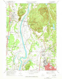
1971 Map of Mt Toby
USGS Topo · Published 1973About this map
The Connecticut River carves a wide path through the center of this landscape, separating the agricultural plains of Sunderland and Whately from the prominent heights of the Mt Toby State Forest. In the early 1970s, the University of Massachusetts campus in Amherst is shown in significant detail, including Alumni Stadium and surrounding residential blocks. The river's influence on local infrastructure is evident at the Sunderland Bridge and the small riverside settlement of North Hadley.
Find a feature on this map
91 named features on this map. Tap any name to fly to it.
Don’t see what you’re looking for? This feature index may not catch every label — zoom into the map to look around manually.
Map Details
Editions of this 1971 Mt Toby Map
2 editions found
Other maps of this area

1885 · Northampton
USGS Topo · 1:62,500

1886 · Northampton
USGS Topo · 1:62,500

1887 · Warwick
USGS Topo · 1:62,500

1887 · Belchertown
USGS Topo · 1:62,500

1889 · Warwick
USGS Topo · 1:62,500

1890 · Belchertown
USGS Topo · 1:62,500

1890 · Greenfield
USGS Topo · 1:62,500

1891 · Northampton
USGS Topo · 1:62,500

1893 · Northampton
USGS Topo · 1:62,500

1893 · Belchertown
USGS Topo · 1:62,500