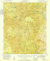
1949 Map of Mt. Union
USGS Topo · Published 1949About this map
Mt Union and its surrounding high-country peaks dominate this mid-century survey of the Prescott National Forest. The landscape is a network of mid-elevation mining claims and ranching outposts, connected by the historic Senator Highway. Small mountain settlements like Groom Creek, Walker, and Venezia are scattered throughout the timbered terrain, reflecting a era of active forest management and lingering mineral extraction. Mining history is prominent here, with sites such as the Snowdrift Mine, Cash Mine, and St Theresa Mine documented alongside more remote locations like Palace Station. In the eastern reach, the Atchison Topeka and Santa Fe railroad corridor skirts the edge of Big Bug Mesa at Poland Jct. The map also captures local gathering places and summer camps, including the Baptist Assembly, Girl Scout Camp, and Phoenix YMCA Camp near Goldwater Lake.
Find a feature on this map
111 named features on this map. Tap any name to fly to it.
Don’t see what you’re looking for? This feature index may not catch every label — zoom into the map to look around manually.
Map Details
Editions of this 1949 Mt. Union Map
2 editions found
Other maps of this area

1887 · Prescott
USGS Topo · 1:250,000

1892 · Prescott
USGS Topo · 1:250,000

1903 · Bradshaw Mountains
USGS Topo · 1:125,000

1903 · Congress
USGS Topo · 1:125,000

1904 · Congress
USGS Topo · 1:125,000

1905 · Jerome
USGS Topo · 1:125,000

1944 · Mingus Mountain
USGS Topo · 1:62,500

1947 · Mingus Mtn
USGS Topo · 1:62,500

1947 · Crown King
USGS Topo · 1:62,500

1947 · Bumblebee
USGS Topo · 1:62,500