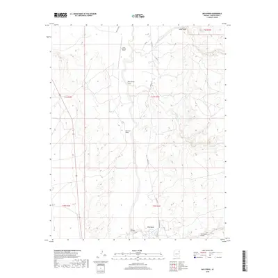
2018 Map of Mud Spring
USGS Topo · Published 2018About this map
Beautiful Valley dominates the central landscape of this Apache County region, where the high desert is carved by a complex network of seasonal drainages. In the north, the Chinle Municipal Airport serves as a modern touchpoint amidst a terrain defined by deep topographic relief and significant geological features. The hydrology of the area is governed by several major washes, including Tiis Nditsooi Wash, Nazlini Wash, and Tse Deeshhaai Wash, which illustrate the natural paths of water across this arid expanse. Named canyons such as Three Turkey Canyon and Little White House Canyon highlight the erosional history of the plateaus. Transportation through this remote stretch is marked by a series of tribal routes, notably Indian Rte 27 and Rte 8071, which connect localized landmarks like Flat Rock and the namesake Mud Spring.
Find a feature on this map
22 named features on this map. Tap any name to fly to it.
Don’t see what you’re looking for? This feature index may not catch every label — zoom into the map to look around manually.
Map Details
Editions of this 2018 Mud Spring Map
This is the sole edition of this map. No revisions or reprints were ever made.
Other maps of this area

1886 · Fort Defiance
USGS Topo · 1:250,000

1892 · Fort Defiance
USGS Topo · 1:250,000

1892 · Canyon De Chelly
USGS Topo · 1:250,000

1954 · Shiprock
USGS Topo · 1:250,000

1954 · Gallup
USGS Topo · 1:250,000

1955 · Chinle 4 NE
USGS Topo · 1:24,000

1955 · Zith-Tusayan Butte 2 NW
USGS Topo · 1:24,000

1955 · Chinle 4 SE
USGS Topo · 1:24,000
1955 · Sonsala Butte 3 SW
USGS Topo · 1:24,000
1955 · Sonsala Butte 3 NW
USGS Topo · 1:24,000