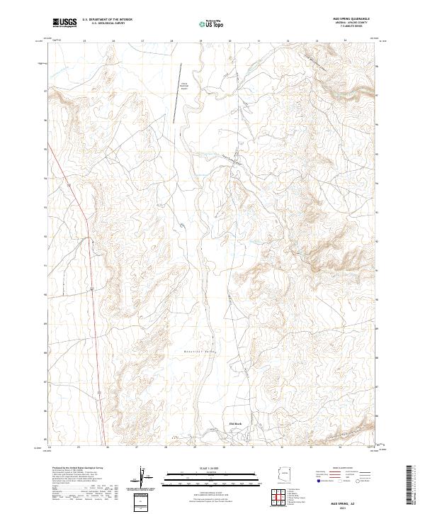
2021 Map of Mud Spring
USGS Topo · Published 2021About this map
Beautiful Valley dominates the central portion of this Apache County landscape, defined by a network of drainage washes that carve through the high desert. The Chinle Municipal Airport sits near the northern edge, serving as a modern landmark in a region otherwise shaped by natural landforms and traditional transport routes. The drainage patterns of Nazlini Wash, Cottonwood Wash, and Tlis Ndiitsooi Wash converge to define the local topography, highlighting the hydraulic significance of these seasonal waterways.
Find a feature on this map
22 named features on this map. Tap any name to fly to it.
Don’t see what you’re looking for? This feature index may not catch every label — zoom into the map to look around manually.
Map Details
Editions of this 2021 Mud Spring Map
This is the sole edition of this map. No revisions or reprints were ever made.
Other maps of this area

1886 · Fort Defiance
USGS Topo · 1:250,000

1892 · Fort Defiance
USGS Topo · 1:250,000

1892 · Canyon De Chelly
USGS Topo · 1:250,000

1954 · Shiprock
USGS Topo · 1:250,000

1954 · Gallup
USGS Topo · 1:250,000

1955 · Chinle 4 NE
USGS Topo · 1:24,000

1955 · Zith-Tusayan Butte 2 NW
USGS Topo · 1:24,000

1955 · Chinle 4 SE
USGS Topo · 1:24,000
1955 · Sonsala Butte 3 SW
USGS Topo · 1:24,000
1955 · Sonsala Butte 3 NW
USGS Topo · 1:24,000