1979 Map of Muddy Valley
USGS Topo · Published 1992About this map
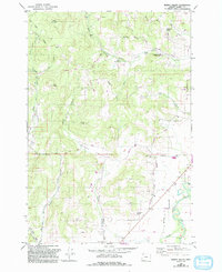
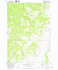
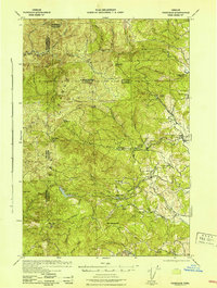
The South Yamhill River anchors the southeastern corner of this Yamhill County landscape, where the valley floor transitions into the timbered slopes of Slide Mountain and The Butte. This 1970s record, updated in the early 1990s, reveals a rural economy centered on the drainages of Muddy Creek and Baker Creek. Local history is preserved at the Happy Valley Cem and South Yamhill Cem, while the Erratic Rock Wayside highlights a unique geological landmark left by glacial floods. A network of family-named roads, such as Bennette Road and Youngberg Hill Road, connects the small settlement at Orchard View with public lands like Huber County Park, reflecting the era's balance of agricultural production and conservation.
Find a feature on this map
53 named features on this map. Tap any name to fly to it.
Don’t see what you’re looking for? This feature index may not catch every label — zoom into the map to look around manually.
Map Details
Editions of this 1979 Muddy Valley Map
2 editions found
Other maps of this area

1924 · Mc Minnville
USGS Topo · 1:48,000

1926 · Mc Minnville
USGS Topo · 1:62,500

1940 · McMinnville
USGS Topo · 1:62,500

1941 · Yamhill
USGS Topo · 1:62,500

1942 · Sheridan
USGS Topo · 1:62,500

1942 · Yamhill
USGS Topo · 1:62,500
1942 · Fairdale
USGS Topo · 1:62,500

1948 · Vancouver
USGS Topo · 1:250,000

1950 · Vancouver
USGS Topo · 1:250,000

1950 · Vancouver
USGS Topo · 1:250,000