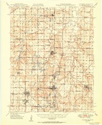
1950 Map of Mulberry
USGS Topo · Published 1950About this map
Strip Mines dominate the topography of the Kansas-Missouri border region, carving out a specialized industrial landscape between Mulberry and Liberal. The map captures a high density of small company towns and settlements, such as Red Onion, Coalvale, and Croweburg, which grew around the coal extraction efforts. The transportation network is defined by the St Louis - San Francisco and Kansas City Southern railroads, which served as the primary conduits for moving the region's mineral wealth.
Find a feature on this map
90 named features on this map. Tap any name to fly to it.
Don’t see what you’re looking for? This feature index may not catch every label — zoom into the map to look around manually.
Map Details
Editions of this 1950 Mulberry Map
2 editions found
Other maps of this area

1884 · Fort Scott
USGS Topo · 1:125,000

1886 · Nevada
USGS Topo · 1:125,000

1886 · Joplin
USGS Topo · 1:125,000

1886 · Fort Scott
USGS Topo · 1:125,000

1886 · Carthage
USGS Topo · 1:125,000

1893 · Fort Scott
USGS Topo · 1:125,000

1894 · Nevada
USGS Topo · 1:125,000

1894 · Joplin
USGS Topo · 1:125,000

1894 · Carthage
USGS Topo · 1:125,000

1939 · Deerfield
USGS Topo · 1:24,000