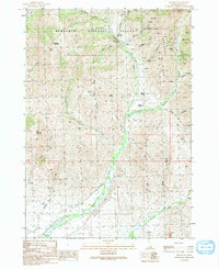
1991 Map of Muldoon
USGS Topo · Published 1991About this map
Muldoon sits in a high drainage where mining operations and national forest management meet. This 1991 provisional map documents a landscape defined by the legacies of silver and lead extraction, with the Idaho Muldoon Mine, Muldoon Mine, and Mutual Mine clustered in the steep gulches of Muldoon Ridge. Evidence of the area's industrial past is seen at Smelter Butte and various ruins and adits found along Argosy Creek.
Find a feature on this map
41 named features on this map. Tap any name to fly to it.
Don’t see what you’re looking for? This feature index may not catch every label — zoom into the map to look around manually.
Map Details
Editions of this 1991 Muldoon Map
This is the sole edition of this map. No revisions or reprints were ever made.
Other maps of this area

1895 · Hailey
USGS Topo · 1:125,000

1897 · Hailey
USGS Topo · 1:125,000

1935 · MacKay
USGS Topo · 1:96,000

1955 · Idaho Falls
USGS Topo · 1:250,000

1955 · Hailey
USGS Topo · 1:250,000

1958 · Idaho Falls
USGS Topo · 1:250,000

1959 · Hailey
USGS Topo · 1:250,000

1960 · Muldoon Canyon
USGS Topo · 1:62,500

1962 · Hailey
USGS Topo · 1:250,000

1967 · Baugh Creek
USGS Topo · 1:24,000