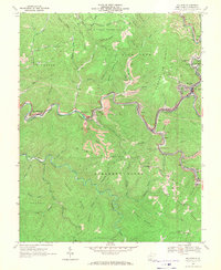
1967 Map of Mullens
USGS Topo · Published 1971About this map
Guyandotte River coal towns and timbered ridges define this 1967 study of Wyoming County. The regional economy is written into the landscape through the winding routes of the Norfolk and Western railway and a proliferation of strip mines, shafts, and tipples. Significant company towns and local hubs like Mullens, Itmann, and Alpoca follow the narrow river valleys, while higher elevations are occupied by landmarks such as Twin Falls State Park and Slab Fork Ridge. Genealogy resources are scattered throughout the hills, including the Bower Cem and Hickory Ridge Cem, alongside civic institutions like the Slab Fork Sch and St Johns Ch. The map illustrates a mature industrial landscape where infrastructure like a Compressor Station and a major pipeline cut across the natural drainage of Pinnacle Creek and Barkers Creek.
Find a feature on this map
58 named features on this map. Tap any name to fly to it.
Don’t see what you’re looking for? This feature index may not catch every label — zoom into the map to look around manually.
Map Details
Editions of this 1967 Mullens Map
2 editions found
Other maps of this area

1887 · Pocahontas
USGS Topo · 1:125,000

1891 · Tazewell
USGS Topo · 1:125,000

1891 · Pocahontas
USGS Topo · 1:125,000

1891 · Oceana
USGS Topo · 1:125,000

1891 · Raleigh
USGS Topo · 1:125,000

1893 · Oceana
USGS Topo · 1:125,000

1894 · Pocahontas
USGS Topo · 1:125,000

1895 · Tazewell
USGS Topo · 1:125,000

1895 · Pocahontas
USGS Topo · 1:125,000

1897 · Tazewell
USGS Topo · 1:125,000