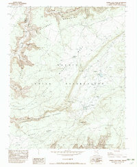
1982 Map of Mummy Cave Ruins
USGS Topo · Published 1982About this map
Navajo Indian Reservation lands dominate this study of the canyons and mesas in Apache County, where the landscape is defined by the deep incisions of Canyon Del Muerto and Canyon De Chelly. The map identifies significant archaeological and ancestral sites, including the Mummy Cave Ruins and Yucca Cave Ruins, alongside markers of later conflicts such as Massacre Cave (Site). The plateau surface of Middle Mesa and Little Mesa is marked with isolated ranching infrastructure like Frozen Feet Windmill WM and numerous corrals, connected by the Twin Trail. This landscape reveals a long history of human habitation, from ancient cliff dwellings in Giant Canyon to modern water management features like Garden Dam and Twins Dams, reflecting the persistent importance of the canyon systems for shelter and resources.
Find a feature on this map
36 named features on this map. Tap any name to fly to it.
Don’t see what you’re looking for? This feature index may not catch every label — zoom into the map to look around manually.
Map Details
Editions of this 1982 Mummy Cave Ruins Map
This is the sole edition of this map. No revisions or reprints were ever made.
Other maps of this area

1892 · Canyon De Chelly
USGS Topo · 1:250,000

1954 · Shiprock
USGS Topo · 1:250,000

1955 · Sonsala Butte 2 SW
USGS Topo · 1:24,000

1955 · Sonsala Butte 4 NW
USGS Topo · 1:24,000

1955 · Sonsala Butte 3 SE
USGS Topo · 1:24,000

1955 · Sonsala Butte 2 SE
USGS Topo · 1:24,000
1955 · Sonsala Butte 3 NE
USGS Topo · 1:24,000
1955 · Sonsala Butte 3 SW
USGS Topo · 1:24,000

1955 · Sonsala Butte 1 SW
USGS Topo · 1:24,000
1955 · Sonsala Butte 4 SW
USGS Topo · 1:24,000