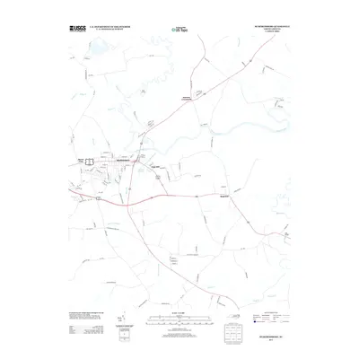
2013 Map of Murfreesboro
USGS Topo · Published 2013About this map
Murfreesboro serves as the focal point of this landscape, situated along the southern banks of the Meherrin River. The geography is defined by a dense network of slow-moving waterways and wetlands, such as Worrell Mill Swamp and Old Tree Swamp, which drain into larger tributaries like Potecasi Cr. Historically, the river provided vital access as evidenced by Shell Landing, while local industry and milling were anchored at Worrell Millpond. Smaller rural communities including Barretts Crossroads and Mapleton are connected by a web of local roads, reflecting the agricultural and residential patterns of Hertford County in the early 21st century. The map illustrates how development in High Hill and Buena Vista has grown outward from the town center while remaining deeply intertwined with the surrounding riparian environment.
Find a feature on this map
110 named features on this map. Tap any name to fly to it.
Don’t see what you’re looking for? This feature index may not catch every label — zoom into the map to look around manually.
Map Details
Editions of this 2013 Murfreesboro Map
This is the sole edition of this map. No revisions or reprints were ever made.
Other maps of this area

1908 · Winton
USGS Topo · 1:62,500

1919 · Boykins
USGS Topo · 1:48,000

1920 · Holland
USGS Topo · 1:62,500

1920 · Boykins
USGS Topo · 1:62,500

1943 · Holland
USGS Topo · 1:62,500

1953 · Norfolk
USGS Topo · 1:250,000

1957 · Holland
USGS Topo · 1:62,500

1966 · Sunbeam
USGS Topo · 1:24,000
1966 · Boykins
USGS Topo · 1:24,000
1967 · Riverdale
USGS Topo · 1:24,000