1943 Map of Murrieta
USGS Topo · Published 1943About this map
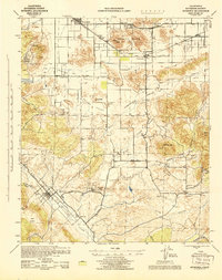
The Atchison Topeka and Santa Fe railroad corridor anchors this 1943 topographical study, connecting the settlements of Romoland and Winchester across a landscape of broad alluvial valleys and granite heights. Long before the suburban expansion of the modern Inland Empire, this region was defined by a series of distinct basins including Menifee Valley, Paloma Valley, and Domenigoni Valley. The map details a rural infrastructure of namesake schools like Menifee Sch and Alamos Sch, alongside small localized industry such as the Leon Mine. Natural drainage patterns are clearly delineated, with Murrieta Creek and Warm Springs Creek converging near the town of Murrieta. At the western edge, the Lake Elsinore Country Club and the Railroad Canyon Res mark the early development of recreation and water management in this mediterranean climate.
Find a feature on this map
51 named features on this map. Tap any name to fly to it.
Don’t see what you’re looking for? This feature index may not catch every label — zoom into the map to look around manually.
Map Details
Editions of this 1943 Murrieta Map
This is the sole edition of this map. No revisions or reprints were ever made.
Other maps of this area

1901 · Southern California Sheet No. 1
USGS Topo · 1:250,000

1901 · San Jacinto
USGS Topo · 1:125,000

1901 · Elsinore
USGS Topo · 1:125,000

1901 · San Luis Rey
USGS Topo · 1:125,000

1901 · Riverside
USGS Topo · 1:62,500

1903 · Ramona
USGS Topo · 1:125,000

1904 · Southern California Sheet No. 2
USGS Topo · 1:250,000

1904 · Southern California Sheet No. 1
USGS Topo · 1:250,000

1939 · Palomar Mountain
USGS Topo · 1:62,500

1941 · Margarita Peak
USGS Topo · 1:62,500