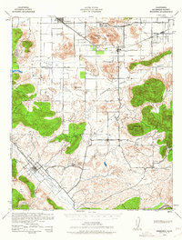
1942 Map of Murrieta
USGS Topo · Published 1962About this map
The Atchison Topeka and Santa Fe railroad corridor anchors this 1942 military survey of Riverside County, tracing a path through Romoland and Winchester during the early war years. The landscape is defined by broad interior basins like Menifee Valley and Domenigoni Valley, where agricultural life is marked by several local institutions including Menifee Sch and Alamos Sch. The presence of the Leon Mine near Bell Mtn and the established Murrieta Hot Springs reflect the region's diverse economic draws, from mineral extraction to early desert tourism.
Find a feature on this map
49 named features on this map. Tap any name to fly to it.
Don’t see what you’re looking for? This feature index may not catch every label — zoom into the map to look around manually.
Map Details
Editions of this 1942 Murrieta Map
2 editions found

Other maps of this area

1901 · Southern California Sheet No. 1
USGS Topo · 1:250,000

1901 · San Jacinto
USGS Topo · 1:125,000

1901 · Elsinore
USGS Topo · 1:125,000

1901 · San Luis Rey
USGS Topo · 1:125,000

1901 · Riverside
USGS Topo · 1:62,500

1903 · Ramona
USGS Topo · 1:125,000

1904 · Southern California Sheet No. 2
USGS Topo · 1:250,000

1904 · Southern California Sheet No. 1
USGS Topo · 1:250,000

1939 · Palomar Mountain
USGS Topo · 1:62,500

1941 · Margarita Peak
USGS Topo · 1:62,500