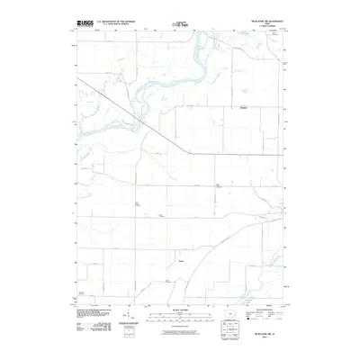
2010 Map of Muscatine NW
USGS Topo · Published 2010About this map
Ardon and Dayfield anchor the rural landscape of Muscatine County, where the meandering Cedar River creates a complex network of waterways including Pike Run and Crane Creek. The terrain is defined by its agrarian roots and the shifting hydrology of the Mississippi River floodplain, visible in the presence of Keokuk Lake and the Muscatine Slough. Local history is deeply etched into the land through a high density of small burial grounds, such as Ardon Cemetery, Saint Johns Cemetery, and the High Prairie Cemetery located near High Prairie Road. In the northern reaches, the map records Camp Sacalawea and Lindle Lake near the confluence of Chicken Creek. The intersection known as Hoot Owl Junction serves as a notable landmark for those tracing the historical road and rail development across these Iowa farmsteads.
Find a feature on this map
39 named features on this map. Tap any name to fly to it.
Don’t see what you’re looking for? This feature index may not catch every label — zoom into the map to look around manually.
Map Details
Editions of this 2010 Muscatine NW Map
This is the sole edition of this map. No revisions or reprints were ever made.
Other maps of this area

1891 · Wilton Junction
USGS Topo · 1:62,500

1894 · West Liberty
USGS Topo · 1:62,500

1901 · Stanwood
USGS Topo · 1:125,000

1948 · Muscatine
USGS Topo · 1:62,500

1953 · Wilton Junction
USGS Topo · 1:24,000

1953 · Blanchard Island
USGS Topo · 1:24,000
1953 · Muscatine
USGS Topo · 1:24,000

1958 · Davenport
USGS Topo · 1:250,000

1961 · Davenport
USGS Topo · 1:250,000

1962 · Davenport
USGS Topo · 1:250,000