
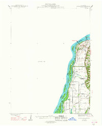
1948 Map of Muscatine
USGS Topo · Published 1948About this map
The Mississippi River corridor dominates this late-1940s survey, revealing a landscape defined by complex hydrology and agricultural drainage in the bottomlands of the Iowa-Illinois border. Downstream from Muscatine, the river is flanked by an intricate network of secondary channels and backwaters like Blanchard Chute and Bogus Chute, enclosing numerous named islands. On the Illinois side, the townships of Drury and Eliza show a heavy reliance on engineered drainage, with features such as Eagle Ditch, Main Ditch, and School Ditch cutting across the floodplains to manage water from Copperas Creek and Eliza Creek. Rural life is anchored by local institutions like Lillibridge Sch, Union Sch, and Lone Elm Sch, serving the scattered farmsteads near the settlement of Excelsior. Large portions of the western half of the map are noted as an Unsurveyed Area, contrasting with the detailed topography of the river bluffs and bottomland lakes like Glancey Lake and Jones Lake.
Find a feature on this map
47 named features on this map. Tap any name to fly to it.
Don’t see what you’re looking for? This feature index may not catch every label — zoom into the map to look around manually.
Map Details
Editions of this 1948 Muscatine Map
2 editions found
Other maps of this area

1890 · Durant
USGS Topo · 1:62,500

1891 · Wilton Junction
USGS Topo · 1:62,500

1894 · Durant
USGS Topo · 1:62,500

1894 · West Liberty
USGS Topo · 1:62,500

1901 · Rock Island
USGS Topo · 1:125,000

1901 · Stanwood
USGS Topo · 1:125,000

1910 · Rock Island
USGS Topo · 1:125,000

1916 · Edgington
USGS Topo · 1:62,500

1935 · Keithsburg
USGS Topo · 1:48,000

1938 · Edgington
USGS Topo · 1:62,500