
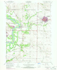
1953 Map of Wilton Junction
USGS Topo · Published 1956About this map
Wilton Junction stands as a significant rail hub in the 1950s, where the Chicago Rock Island and Pacific railroad bisects the landscape. The winding Cedar River dominates the western edge of the quadrangle, bordering the settlement of Moscow. This area of eastern Iowa is characterized by a dense network of rural infrastructure, including numerous one-room schoolhouses such as Champion Hill School and White Prairie School. The survey captures the transition of regional transportation, noting a dismantled railroad line and the presence of the Moscow Airport. Genealogists will find a wealth of local history in the many family and community burial grounds, including the Healy Cemetery, Oakdale Cemetery, and Nine Cemetery, reflecting the early pioneer settlement patterns across townships like Rochester, Sugar Creek, and Bloomington.
Find a feature on this map
38 named features on this map. Tap any name to fly to it.
Don’t see what you’re looking for? This feature index may not catch every label — zoom into the map to look around manually.
Map Details
Editions of this 1953 Wilton Junction Map
2 editions found
Other maps of this area

1890 · Durant
USGS Topo · 1:62,500

1891 · Wilton Junction
USGS Topo · 1:62,500

1894 · Durant
USGS Topo · 1:62,500

1901 · Rock Island
USGS Topo · 1:125,000

1901 · Stanwood
USGS Topo · 1:125,000

1910 · Rock Island
USGS Topo · 1:125,000

1916 · Edgington
USGS Topo · 1:62,500

1938 · Edgington
USGS Topo · 1:62,500

1948 · Muscatine
USGS Topo · 1:62,500
1953 · Bennett
USGS Topo · 1:24,000